Today is Sunday, 26th, and - well - the 'First_Annual_Rob Kells_Memorial_Hang_Gliding_Event' (being run out of / at "The Florida Ridge"
(nearly to LaBelle, Florida (actually about 13 miles east of La Belle
on S.R. (State Road) 80), where I fly 'most' of the time)) was
'blown-out' for the second day in a row (and it may get blown-out the
rest of the week, too, but we wouldn't want to say that in 'Publix'...
For a 'locator' map-image click these: small large (1 Meg) truly (1.5 Megs)_huge and you'll notice a small yellow 'push-pin' in the SW part of the image - that's Florida Ridge, and the other yellow-push-pin in the NE part of the image is where May and Bill live in Stuart, Florida.
Anyway - yesterday, after I drove back to Stuart from the Hang Gliding park, I went kiteboarding and Ms. May watched, and read her book. Today at the (Hang Gliding) event, I ran into Mr.__Konrad _Heilmann_ whom I'd run into at the Hang_Gliding event last summer in Maryland, and we went kiteboarding then, also... Today I loaned him some gear (and the harness I loaned him broke (but we fixed it)) and we had a terrific afternoon on the water. Ms. May was also with us and she went boardsailing on her 5.0 sail and also had a grand time...
Unfortunately 'on-the-water' pictures are really hard (but we'll have to do something about that) - so we don't have any pictures of our water-time, today.
BUT - Then (after kiteboarding) we all went over to the 'abandoned_hotel_on_the_beach' (which is about 10 minutes from the Kiteboarding spot (at USSCMC as we call it)) where we sometimes help others fly in the 'updraft', and about 10 to 15 of the 'competition' hang-glider pilots (read this as some of the best pilots in the world!) were THERE at the beach, flying in front of this old_abandoned_hotel_on_the_beach right near where we go kiteboarding... So - needless to say we watched and helped (pull-people-up into the updraft) for a while - til it got late, and cold (with 20 mph wind coming off the ocean)...
Pictures of this 'hang-fest' will materialize here on the web-site soonish - I "promise" - soon as someone publishes them somewhere and/or they make a DVD and/or we some how beg, borrow, or steal the image-files!...
Went TriceQ-riding with some folks on Tuesday morning (21st) in Cocoa (not "Cocoa Beach"). I was actually on my way to Jacksonville, to visit my Mom, who lives there, but found this ride scheduled and so couldn't pass it up... Met-up with a guy from west of Orlando, who I'd only communicated with, via e-mail, it was great to put a face and a riding-style with a name. We rode along the river and into "Rockledge" another little town south of Cocoa. The ride-part that I was on was less than 15 miles and very scenic, and so-on and so-forth.
Track logs for 'part' of the 'return-trip' here: (track-log from the Apple iPhone with "Motion-X GPS" software) ...
And - another trike-friend from Okeechobee has now asked me to ride 400 miles in late September with him, in the North Carolina Mountains - I'm considering this one.. - I've ridden so long in Flat Florida (notice they both start with "F L") that to ride in the Mountains will be a 'challenge'?!
Today is Sunday, 19th, - today we went for a trike-bike ride along the LOST (Lake Okeechobee Scenic Trail) - for almost 30 miles.. - about 2 1/2 hours - going out was 'fun' but coming back to Port Mayaca was a REAL SLOG with about a 10 mph head-wind (and it was DEAD-on). - we're BOTH HUNGRY when we got back home, so we shared some Tuna and such with Ms. Siew Mei who was patiently waiting at home for us when we got back. Mr. Panda, though had navigated to Port Mayaca for us and took care of the mini-van while we were riding...
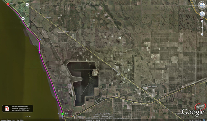
Here's an image of the track-log-file (one-way (south to north))... (click on the image for larger, or click here for huge-(2.2 megabytes)
and here's some other files for your perusal...
Track-log here in ...kmz for your Google Earth
Track-log here in ...gpx for other applications.
Waypoint_S135 (...kmz or ...gpx)
Waypoint_G_68 (...kmz or ...gpx)
Yesterday (Saturday, 18th) we discovered (or RE-discovered) the 'Baseball Rule' - Three SLOGs and you're OUT!... - Sorry - I think in baseball it's, 'Three STRIKEs and you're out...' Mr. Bill tried to go boardsailing- and - yeah - SLOGged across the bay three times (not quite enough wind!) - but on the third return the wind finally came 'up' for just a while - to make it enjoyable for about 3 hours or so - then it died again, but I was alert enough so that I didn't have to swim home... I was getting chilly anyway... it was, though, an EXCELLENT day on the water...
Today is Friday, 17th, and we've been home from Arizona almost a week. - We've had a good week, HOWEVER, poor Ms. Siew Mei (our beloved cat) has not had a great week - just home from the vet, now, but getting better.
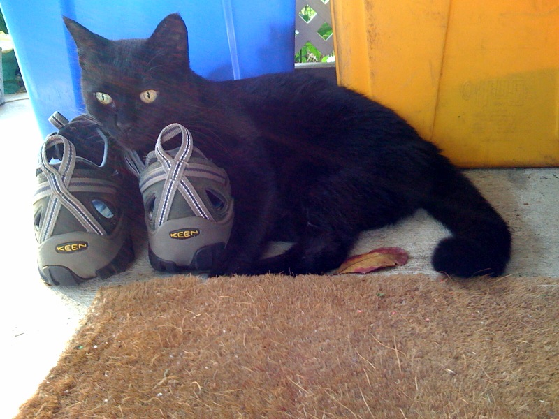
However, while in Arizona I got a new pair of shoes, and she's appointed herself my new shoe(s) "Protector".
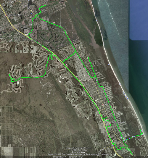
Did 4 trike-rides this week, Monday, Tuesday, Wednesday, and Today (Friday)... Broke the indexing part of the rear (bar-end (or thumb)) shifter (Shimano SL-BS77) but - have ordered new parts (might be in today, might be in next week). Today was the longest-best-trike-ride since we returned... 33.7 miles in 2 hours / 45 minutes for a 'rate' of 12.25 mph, not bad for an old guy like me. Track-log in green is above, overalin on Google Earth's satellite photos. AND I'm using a new software gadget on the Apple Macintosh to download the tracks from the 11-12 year old GPS I use on the Trike. This software tool is called 'LoadMyTracks.app' - and you can view it's details at the Apple Macintosh Downloads web-site and/or at this web-site.
Ms. May is away (temporarily (for the afternoon)) evaluating wood-fire-kilns & such - but she'll be back later - perhaps we'll go boardsailing?
Today is, well - whatever today is - sorry - seem to have forgotten - must be something close to Tuesday, 7th, but WHO KNOWS? (Time flies when you're having fun, huh?)
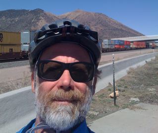
anyway - I(Bill) rented one of them funky bicycles (or larger) with only two wheels and went for a short (24 miles) ride to here ( or larger ).

Along the way I stopped to watch a train go by (on one of two tracks) the train in the 'front' (closest to the camera) is 'moving' the - train in the background is stopped - see if you can detect the 'little-bit-of-distortion' that the digital camera introduces?
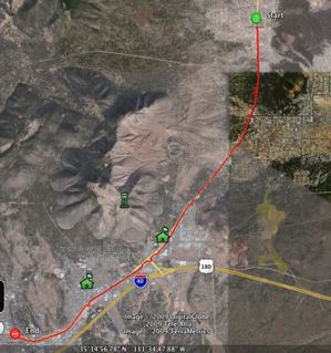
AND - if you're the LEAST BIT INTERESTED (which I FULLY UNDERSTAND most people are NOT) then here's the Track-Log-File(s) (on top of the Google Earth image(s)) from parts of that ride:
If you have some other mapping or earth-resources software that uses the ...gpx format - then you probably know what to do with those ...gpx formatted files.
OR if you LIKE "Google Maps" - ( where YOU DO NOT NEED to have Google Earth on your computer (you only need to use your web-browser!))
Today is Sunday, 5th of April - no - we've not been doing a lot, excepting a tiny bit of hiking - in / around one of the flatest places on earth...
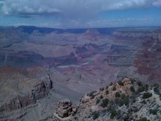
Did a short-hike in the Grand Canyon (Grandview Trail) _ about 90 minutes down (taking pictures and such ( a GREAT DAY for pictures )) and then about another 90 minutes back up... We didn't 'quite' make it to "Horsehoe Mesa" (On the Tonto 'plateau' (we did about 1,600 feet of a 2,600 foot (vertical difference climb / hike) ) but - well - we'd not acclimated to the 7,300 foot elevation of the south rim but, we managed well, anyway...
As Ms. May is wont to say, "Why come to the Grand Canyon unless you're going to hike."
So on Sunday we did a less exotic hike of about 5 miles along the 'rim trail' and then through the Sunset Crater National Volcanic Monument ( see picture below ).
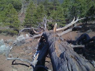
a tree in/around the "Sunset Crater National Volcanic Monument" (kml track-log of the hike down from the top of "Lenox Crater" is here, if you want to see it in ...kmz format (this assumes you've got 'Google Earth' on your computer...
Then a Pottery Workshop in Flagstaff and more in Phoenix, and so on and so forth...
Sorry - today is the first of April (no this is NOT an April Fools Joke!) - and there is 'not much' to report; except Ms. S.M. our beloved cat is (WE HOPE) coming home from a 24 hour stay at the vet and we are getting ready to get away for a while and it's been RAINING here, and well - that's about it for the 'First' of the month - stay tuned - more to come, later this month!
A New ThAng: Mr._Bill has now discovered (for his_iPhone3G_) something called "MotionX GPS" (both 'free-lite' version and a pay-money-for (I think less than $5.00) - see their web-site) - available from these guys: http://www.motionx.com.
Pretty stunning GPS application - it not only takes track-logs and e-mails them to you (or any e-mail address) but also has tremendous 'on-screen-display' (and on th iPhone3G's tiny screen this is an ACCOMPLISHMENT...) - some 'practice' tracks - / brief (very brief) track-logs are here:
(track-log(s) should be up 'soonish' (by 2 or 3 March) - I have them - but they are on another computer - and because of limitations in our house I can't get to the other computer 'right now'...???
Mr. Bill's best hang-gliding-flight (Ever) - see the FlightLog.Org web-page, here...
For a 'locator' map-image click these: small large (1 Meg) truly (1.5 Megs)_huge and you'll notice a small yellow 'push-pin' in the SW part of the image - that's Florida Ridge, and the other yellow-push-pin in the NE part of the image is where May and Bill live in Stuart, Florida.
Anyway - yesterday, after I drove back to Stuart from the Hang Gliding park, I went kiteboarding and Ms. May watched, and read her book. Today at the (Hang Gliding) event, I ran into Mr.__Konrad _Heilmann_ whom I'd run into at the Hang_Gliding event last summer in Maryland, and we went kiteboarding then, also... Today I loaned him some gear (and the harness I loaned him broke (but we fixed it)) and we had a terrific afternoon on the water. Ms. May was also with us and she went boardsailing on her 5.0 sail and also had a grand time...
Unfortunately 'on-the-water' pictures are really hard (but we'll have to do something about that) - so we don't have any pictures of our water-time, today.
BUT - Then (after kiteboarding) we all went over to the 'abandoned_hotel_on_the_beach' (which is about 10 minutes from the Kiteboarding spot (at USSCMC as we call it)) where we sometimes help others fly in the 'updraft', and about 10 to 15 of the 'competition' hang-glider pilots (read this as some of the best pilots in the world!) were THERE at the beach, flying in front of this old_abandoned_hotel_on_the_beach right near where we go kiteboarding... So - needless to say we watched and helped (pull-people-up into the updraft) for a while - til it got late, and cold (with 20 mph wind coming off the ocean)...
Pictures of this 'hang-fest' will materialize here on the web-site soonish - I "promise" - soon as someone publishes them somewhere and/or they make a DVD and/or we some how beg, borrow, or steal the image-files!...
Went TriceQ-riding with some folks on Tuesday morning (21st) in Cocoa (not "Cocoa Beach"). I was actually on my way to Jacksonville, to visit my Mom, who lives there, but found this ride scheduled and so couldn't pass it up... Met-up with a guy from west of Orlando, who I'd only communicated with, via e-mail, it was great to put a face and a riding-style with a name. We rode along the river and into "Rockledge" another little town south of Cocoa. The ride-part that I was on was less than 15 miles and very scenic, and so-on and so-forth.
Track logs for 'part' of the 'return-trip' here: (track-log from the Apple iPhone with "Motion-X GPS" software) ...
- click here for the track-log-file overlain on top of a Google Earth image ( large )
- click here for the track-log-file in ...kmz format
- click here for the track-log-file in ...gpx format
And - another trike-friend from Okeechobee has now asked me to ride 400 miles in late September with him, in the North Carolina Mountains - I'm considering this one.. - I've ridden so long in Flat Florida (notice they both start with "F L") that to ride in the Mountains will be a 'challenge'?!
Today is Sunday, 19th, - today we went for a trike-bike ride along the LOST (Lake Okeechobee Scenic Trail) - for almost 30 miles.. - about 2 1/2 hours - going out was 'fun' but coming back to Port Mayaca was a REAL SLOG with about a 10 mph head-wind (and it was DEAD-on). - we're BOTH HUNGRY when we got back home, so we shared some Tuna and such with Ms. Siew Mei who was patiently waiting at home for us when we got back. Mr. Panda, though had navigated to Port Mayaca for us and took care of the mini-van while we were riding...

Here's an image of the track-log-file (one-way (south to north))... (click on the image for larger, or click here for huge-(2.2 megabytes)
and here's some other files for your perusal...
Track-log here in ...kmz for your Google Earth
Track-log here in ...gpx for other applications.
Waypoint_S135 (...kmz or ...gpx)
Waypoint_G_68 (...kmz or ...gpx)
Yesterday (Saturday, 18th) we discovered (or RE-discovered) the 'Baseball Rule' - Three SLOGs and you're OUT!... - Sorry - I think in baseball it's, 'Three STRIKEs and you're out...' Mr. Bill tried to go boardsailing- and - yeah - SLOGged across the bay three times (not quite enough wind!) - but on the third return the wind finally came 'up' for just a while - to make it enjoyable for about 3 hours or so - then it died again, but I was alert enough so that I didn't have to swim home... I was getting chilly anyway... it was, though, an EXCELLENT day on the water...
Today is Friday, 17th, and we've been home from Arizona almost a week. - We've had a good week, HOWEVER, poor Ms. Siew Mei (our beloved cat) has not had a great week - just home from the vet, now, but getting better.

However, while in Arizona I got a new pair of shoes, and she's appointed herself my new shoe(s) "Protector".

Did 4 trike-rides this week, Monday, Tuesday, Wednesday, and Today (Friday)... Broke the indexing part of the rear (bar-end (or thumb)) shifter (Shimano SL-BS77) but - have ordered new parts (might be in today, might be in next week). Today was the longest-best-trike-ride since we returned... 33.7 miles in 2 hours / 45 minutes for a 'rate' of 12.25 mph, not bad for an old guy like me. Track-log in green is above, overalin on Google Earth's satellite photos. AND I'm using a new software gadget on the Apple Macintosh to download the tracks from the 11-12 year old GPS I use on the Trike. This software tool is called 'LoadMyTracks.app' - and you can view it's details at the Apple Macintosh Downloads web-site and/or at this web-site.
Ms. May is away (temporarily (for the afternoon)) evaluating wood-fire-kilns & such - but she'll be back later - perhaps we'll go boardsailing?
Today is, well - whatever today is - sorry - seem to have forgotten - must be something close to Tuesday, 7th, but WHO KNOWS? (Time flies when you're having fun, huh?)

anyway - I(Bill) rented one of them funky bicycles (or larger) with only two wheels and went for a short (24 miles) ride to here ( or larger ).

Along the way I stopped to watch a train go by (on one of two tracks) the train in the 'front' (closest to the camera) is 'moving' the - train in the background is stopped - see if you can detect the 'little-bit-of-distortion' that the digital camera introduces?

AND - if you're the LEAST BIT INTERESTED (which I FULLY UNDERSTAND most people are NOT) then here's the Track-Log-File(s) (on top of the Google Earth image(s)) from parts of that ride:
- part_1.kmz part1.gpx
- part_2.kmz part2.gpx part2.jpg (a picture (the same as the 'to here' a couple of lines above))
- part_3.kmz part3.gpx and/or if you want the hugest-thing-on-the-planet, click here (still only about 300 k bytes)
If you have some other mapping or earth-resources software that uses the ...gpx format - then you probably know what to do with those ...gpx formatted files.
OR if you LIKE "Google Maps" - ( where YOU DO NOT NEED to have Google Earth on your computer (you only need to use your web-browser!))
Today is Sunday, 5th of April - no - we've not been doing a lot, excepting a tiny bit of hiking - in / around one of the flatest places on earth...

Did a short-hike in the Grand Canyon (Grandview Trail) _ about 90 minutes down (taking pictures and such ( a GREAT DAY for pictures )) and then about another 90 minutes back up... We didn't 'quite' make it to "Horsehoe Mesa" (On the Tonto 'plateau' (we did about 1,600 feet of a 2,600 foot (vertical difference climb / hike) ) but - well - we'd not acclimated to the 7,300 foot elevation of the south rim but, we managed well, anyway...
As Ms. May is wont to say, "Why come to the Grand Canyon unless you're going to hike."
So on Sunday we did a less exotic hike of about 5 miles along the 'rim trail' and then through the Sunset Crater National Volcanic Monument ( see picture below ).

a tree in/around the "Sunset Crater National Volcanic Monument" (kml track-log of the hike down from the top of "Lenox Crater" is here, if you want to see it in ...kmz format (this assumes you've got 'Google Earth' on your computer...
Then a Pottery Workshop in Flagstaff and more in Phoenix, and so on and so forth...
Sorry - today is the first of April (no this is NOT an April Fools Joke!) - and there is 'not much' to report; except Ms. S.M. our beloved cat is (WE HOPE) coming home from a 24 hour stay at the vet and we are getting ready to get away for a while and it's been RAINING here, and well - that's about it for the 'First' of the month - stay tuned - more to come, later this month!
A New ThAng: Mr._Bill has now discovered (for his_iPhone3G_) something called "MotionX GPS" (both 'free-lite' version and a pay-money-for (I think less than $5.00) - see their web-site) - available from these guys: http://www.motionx.com.
Pretty stunning GPS application - it not only takes track-logs and e-mails them to you (or any e-mail address) but also has tremendous 'on-screen-display' (and on th iPhone3G's tiny screen this is an ACCOMPLISHMENT...) - some 'practice' tracks - / brief (very brief) track-logs are here:
- Brief Track-log 1 - (compiled Google Earth format (you need Google Earth on YOUR computer to click on this))... this is a VERY brief one while riding the Trice Q along the Lake_Okeechobee_Scenic_Trail ("_L.O.S.T._")
- Brief Track-log 2 - (compiled Google Earth format (you need Google Earth on YOUR computer to click on this))... this is a LONGER track-log along the "_L.O.S.T._"
- Brief Track-log 3 - (compiled Google Earth format (you need Google Earth on YOUR computer to click on this))...(this one is in the car from our home to our 'kite-park' (a ...kmz file
- This is a ...jpg IMAGE file of the above Brief Track-log 3 image-file
(track-log(s) should be up 'soonish' (by 2 or 3 March) - I have them - but they are on another computer - and because of limitations in our house I can't get to the other computer 'right now'...???
Mr. Bill's best hang-gliding-flight (Ever) - see the FlightLog.Org web-page, here...
and-or see the track-log over Google Earth Image(s), here... small_image larger_image (1 megabyte)
Archived BeachWeb monthly site(s): Click here for a list of the archived months
Some people have asked, WHERE can I FIND, "X" - whatever the heck "X" is?; but in my case - these two things are being asked about...
The "Tire Changing Web-Page" and/or the VANC (VikingAsia (Networks and Computers) Consulting) web-page.
AND / OR if you 'WANT' (or desire or need or have an 'urge' for something you don't see, then you can e-mail me at: bill@vikingasia.org
updated: 22:27 p.m. on Sunday 26 April, 2009 (Stuart, Florida, time) - revID: 1h