 May-2009 at
the "Beach Club"
Sunday, 31st of May - last day of the month - Ho-Hum -
We went to the "LOST" today (LOST = Lake Okeechobee Scenic Trail) and rode a long way - Mr. Bill did 55.6 miles, Ms._May did about 46 miles - it was long and hot (but no dust and not much sun (mostly overcast, though the last hour was sunny and HOT) and not much wind (less than 3 mph all morning (we rode from about 07:30 a.m. til abut 12:30 p.m. - about 5 hours)).
Track-log-file(s): ...kml ...gpx overlays: small medium hugeomongously_BIG
We visited for a few minutes with our friend Mr._Gary from _Okeechobee_, whom we met while riding on the dike. He thought Ms._May was 'virtual' but now that he has met her he realizes she's real...
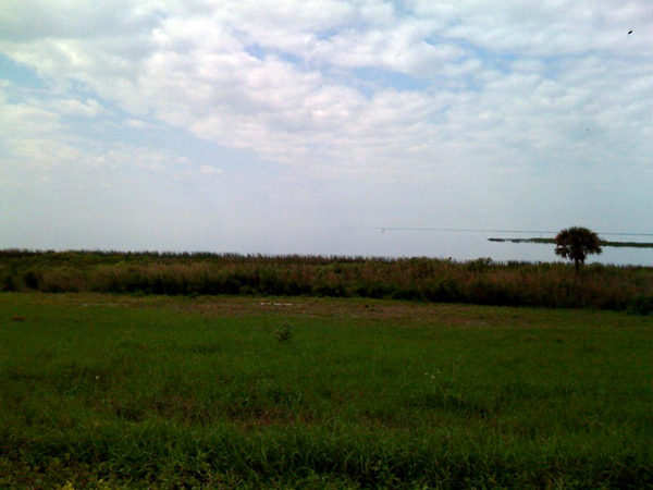
it was "One of those Days" where one can not find the beginning or the end of the sky or the 'horizon' (the water), reminds me of the Jim Carey movie where he was raised on the set of some TV show, but he didn't know it - and he set-sail across the lake one day and ran-into the far-wall... - Don't remember the name of the movie but it was 'o.k.', but when one looked at the lake and the sky today - it was really hard to tell...
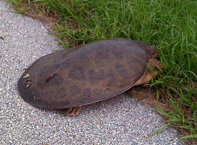
Oh, and here's someone ELSE (read below) who was trying to cross the dike, today...
Friday, 29th: - a short (44 mile) trike-ride today - managed to see quite a few turtles crossing various roads
small turtle picture here larger turtle picture here
a couple of crabs (doing the same thing) some squirrels, birds, lizards, and various & sundry other wildlife (as one normally does). The turtles, though, were a particular treat (it's rained a LOT, lately, so we expect they are looking for drier domiciles?), especially when one has to park one's trike in the middle of the street to let the toi-toi finish crossing the road.
Several drivers, though, helped other turtles crossing other roads. Drivers tend to be more impatient than turtles, who seem to have 'all day' to cross a single road?
AND I found a 'geocahe' yesterday - and stopped, today, to take a picture and such... The one I found was " GC1A41W " - which you can review either with the "Track-Log-File" taken today ( ...kml version or ...gpx version ) - or you can use the " Geocaching Web Site here " to review geocahes, that have been set-up and/or learn-more about this interesting, educational, and growing 'sport' where technical knowledge and sophistication works alongside personal 'stick-to-it-iveness' amongst other positive personal traits to be excellent at this endeavour...
and - lastly - images of the track-log of the ride, today (44 miles is 'not bad' but not 'a personal best' - maybe Sunday might do 60 or 70 miles))
small ( 352 k bytes) medium ( 796 k bytes) super-duper-larger ( 1.2 megabytes)
Friday, 29th: An 'end-of-a-life' here at the Beach Club - but no "Murder Mystery"...
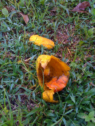
Apparently the mangoes are now ripe - it's NOT a 'mystery' as to who is eating them during the darkest-hours, around here. MAYBE we'll get a few more than we got last year...
The "new Kiln" might show-up today - it was supposedly shipped from New York on Tuesday. However, we have not had a phone-call about the delivery, so who knows
It rained AGAIN last night - more and more and more rain - we'll have to 'do some serious weeding' here really soon - as somehow the raindrops fall ONLY on the weeds, not on the grass.
AND _ the trike-riding continues - about 24.2 miles yesterday - late morning - and found that the 'tea-flavour' of the PowerBar Endurance Drink is not the most tasty stuff in the world, but it really does a good job of hydrating, - better that "G"... - but our experimentation continues...
AND - well - we continue to long for more wind to go kiteboarding in - perhaps a 'positive' thinking attitude will help - but one knows one can rarely influence the weather, even with positive thinking...
The last day of the '3-day-Memorial-day-weekend'...
Monday, 25th May, - short trip up the Loxahatchee River in our kayaks ... - take your pick of the pics (some by Ms._May(Nikon), some by Mr._Bill (iPhone)) - we'll leave it up to you to figure out which is which... ... ...
Sunday, 24th May;

- had an amazing trike-ride, today - 'longest' for me, ever - 52.2 miles / 4 1/2 hours (or so) - but lost a piece of one of my flags / flagstaff - ugh ugh - drove around quite a while in the car, still didn't find it - ugh ugh UGH... - but - well still a great ride - and though it was overcast it didn't rain and I didn't get cold at all - though I did have to stop twice and pump-up the right tire , then eventually changed the right tube when I said I just was NOT going to stop a third time to pump it up - so I changed it! (but - eventually (at home) found a huge piece of glass in the tire (which explains why two tubes went flat!) Did some maintenance work on the Trike - replaced 'factory' plastic rim-strips with cloth rim-strips - and re-inflated all tires to 65 psi - and - CLEANED it UP - riding on wet-roads makes the trike DIRTY...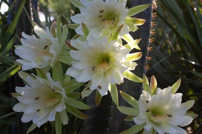
AND - AND - AND - Ms. May was alert and awake and HERE when our cactii blossomed this morning - and she took this picture... - NOTICE all the honey-bees on the flowers - Ms. May says the honey-bees really like these flowers - and they don't just go IN and come OUT - they go INTO the flower and stay there a long time (I'm guessing because Honey Bees like HONEY-making pollen and these flowers are only open a little while (1-4 days, usually) and so the honey-bees are trying to get all they can...
HoneyBees remind me of Mr. Pooh Bear - a Bear of Very Little Brain (kind of like Mr. Bill) (Silly Bear!)
Today is Friday, 22 May
We have had 'some' excitement (a LOT of RAIN all WEEK) that has thrown our normal (great windy days) into oblivion because of the thunder and lightning
Even though we got new pieces and parts for Ms._May's new kiteboarding-control-bar ( hers on the left (small) , mine on the right (large)), and I rigged all that up for her... after her short but excellent kiteboard episode on the 17th... ( large small )
Even though I rode my trusty trike in the RAIN for 3 1/2 hours - (UGH UGH!) track-log-here: large small
Even though we just put in this new irrigation system, but now it has RAINED for almost a week, non-stop. (This may be why it rained; because we have a new irrigation system?)
Even though I'll just BET some silicon supplier put a little tiny 'chip' inside EACH rain drop so that a week's worth of rain fell ONLY on the WEEDs, and not on the (pathetically little) grass that we have, so now there will be little to mow, but lots to weed
Even though I THINK, that now maybe our mangoes will ripen and we'll get more than we got last year...
WELL - more days of holiday to come!
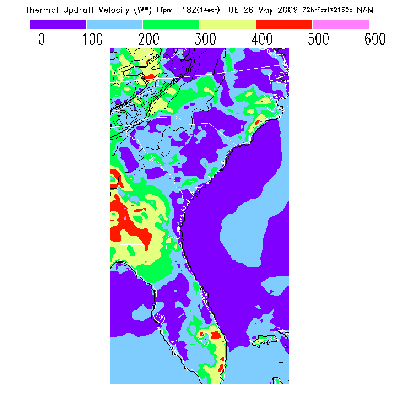
and doesn't look like much hang-gliding on Monday (and Sunday looks even worse)
Today is Friday, 15 May
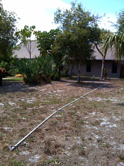
picture of 'part of' the 'new (and improved)' irrigation system in our front yard...
Yesterday there was 'just enough' (but not more than enough) wind for Mr. Bill to get some excellent kiteboarding in, (after 3 hours of digging-ditches yesterday morning and before 2 hours of 'gluing' the new irrigation system together last evening...
Today is Monday, 11th May, and we're here in Stuart, - home-sweet-home...
The "2009 Flytec Race-Rally Hang Gliding Competition" ended at "Quest Air" in Groveland, Florida (just west of Orlando, Florida) on Saturday evening, the 9th... The event was 'supposed' to end at "Lookout Mountain Flight Park" in Rising Fawn, Georgia (about 20 miles south of Chattanooga, Tennessee) but - well - the weather reared it's ugly head and the bulk of the participants drove back to Quest Air and finished the last two 'tasks' there...
AND - of course the " (First) Rob Kells Memorial Hang Gliding event is now over at "The Florida Ridge" - one can view results here:
Flex-wing glider results (Flex-wings are the most popular, low cost, (like $4,000 - $10,000 and the type that Ms._May and I own)
Rigid-wing glider results (Rigid-wings are for 'REAL PEOPLE' (mostly guys!)) - and big, heavy, (fast) and expensive (like $10,000 - $45,000)
Sport class glider results (Sport Class is for beginners at cross-country (like me - this is where I would compete if I were 'up to it' (which I'm not))
Ms. May took some pictures of that event on Thursday morning, 30th April, while we were launching the pilots / gliders. Those images are now in my "Gallery" (web) page here...
Saturday, (9th) and today (11th) were TriceQ riding days and they were excellent with 31.7 miles and 23.4 miles (respectively)... Had yet one more flat-tire - I think I must be doing something wrong, here??? - Will have to investigate & change my habits, I guess...
We both went hang-gliding on Sunday, 10th (Mother's Day (did you phone your mother????)), and Mr. Bill set a new 'personal best' height record of 7,634 feet (about 7,600 feet above the field at "The Florida Ridge").
I probably could have made the extra 400 feet or so to get to a new personal best of 8,000 feet, but I most probably would have been an icicle and I would DEFINITELY have been INSIDE a cloud; neither of these options is a 'Good Thing' when you're hang-gliding. It was an hour and 41 minute flight for me...
A REAL record was set by Mr._Brad, one of the other (local (Ridge)) pilots, 9,000 something feet - and WOW that's (really) high for Florida (at this time of year (or actually that's HIGH for Florida at ANY time of year) and a new record for a "Florida Ridge" pilot. On the other hand, Mr._Brad is a pretty spectacular pilot. Another local pilot (Eric) set his new personal best at 8,300 feet.
Ms. May took some excellent pictures of me landing after one of my flights on Sunday, 10th. Those pictures are on the Gallery site here...
Ms. May also had a good flight - no personal bests, there, but a good flight never-the-less. It was terrific to see the huggly-bunch in the air, again, as it's been quite a while for her... Today was the first day that she used the Garmin GPSMap 76CSx to create a 'track-log' of her flight. There's two 'simple' images, here, with (one of) her track-logs overlain on top of a 'Google Earth' satellite image:
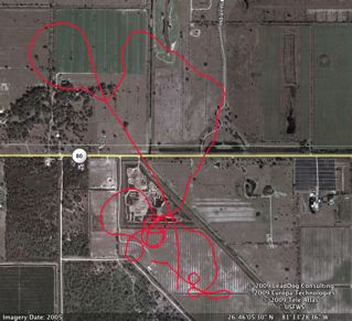
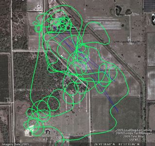
Ms. May's first flight at the "Ridge" on Sunday, 10th Ms. May's second flight at the "Ridge" on Sunday, 10th...
Now that I've downloaded those two flights' track-logs, I'm still attempting to get the 1/2 dozen different pieces of software on the 1/2 dozen different computers to exhibit 'just the right' set of characteristics... - UGH UGH - modern technology, you know....
However, I have (now, reliably) figured out how to get 'curtained' track-logs in Google Earth / overlain on top of the satellite imagery provided by Google Earth...
The following image of of Ms._May's short (first) flight on Sunday, 10th is in this format. However, you may or may not 'make sense' of this format if you are not a pilot.
1.) I'd like to be able to offer a 'click here link' so that our friends & relations can view "in 3D" the track-log files - which of course have that 'extra dimension' (altitude)
2.) I'd like to be able to offer a 'click here link' so that our friends & relations can see an 'animation' of our flight(s) along the 3D path - expressed or offered in Google Earth
I can not, now, do either of these things "RELIABLY" _ I've done each but only in different software tools - primarily on the Windows XP platform, with only pieces available to the Macintosh (PowerPC) platform user? - HOWEVER, I know that as time goes by and as I get more proficient (and maybe lose more hair) that 'all things will be possible'!
Today is (early (EARLY)) morning of Wednesday, 6th May, and this morning the 'Flytec Race Rally' is in Moultrie, Georgia... (over 1/2 way to the finish at Lookout Mountain Flight Park near Trenton, Georgia, and if you can't find that on the map, it's about 20 miles south of Chattanooga, Tennessee...
Anyway - NO ONE made it to "goal" on Tuesday (going into Williston, Florida) and NO ONE made it to "goal" last night coming into here (Moultrie, Georgia)... Most of the gang went-down 'around-about' Live Oak, Florida - very near to the intersection of US Interstate 10 and US Interstate 75 (VERY BIG Highways!)...
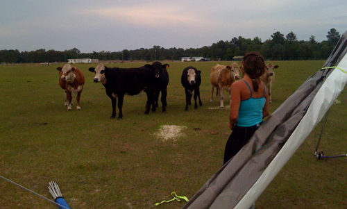
When I picked-up Ms._Linda, she had a LOT of help breaking-down her glider.
Then we had dinner (excellent sub-sandwiches) in Quitman, Georgia and when we drove into Moultrie last night about 8:30 p.m. or so there were a LOT of wet - streets roads, and we set-up the pop-up-trailer in the drizzle...
This morning - it's still raining / misting a 'bit' and a the Moultrie Airport, here, there is some definite fog...
For results of this event you can go to: http://soaringspot.com/flytec2009
For more information from the "Source" you can find Ms._Linda's "Blogspot" here.
Today is Monday, 4th May, and the second day of the Flytec Race-Ralley Hang Gliding event - yesterday's field had about 2/3 in goal (of over 200 km)...
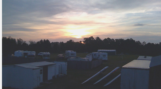
Sunrise at Quest Air in Groveland, Florida (near Orlando)...
I'm doing a lot of driving - these days (that's what they pay me for, anyway) - will do a lot more - in the past my lovely and talented wife / navigator has helped me a LOT... I'm now driving for a terrific couple of pilots from western New_York, and they have kind of a small car, and Ms._May did not want to come, anyway.

So the couple felt sorry for me and found me a "" driving partner "" - she's very good at keeping quiet, but she's not the best (opposing thumbs and all that stuff) with the navigation & communications tools (GPS, radio, cell-phone, etc.), and she doesn't like french-fries but she DOES LIKE fish sandwiches... She also has a great 'body-mass' which helps keep me warm on the cold evenings...
Today is Sunday, 3 May, and the first day of the Flytec Race-Rally Hang Gliding event - we'll only know tonite how successful this first day was / is... This is a 7 day / 700 mile (if the weather cooperates and we make it all the way) event. This format has never been attempted in the USA - so wish us luck!!!
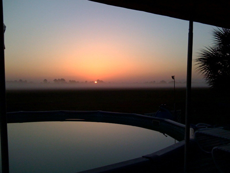
However, here's a sunrise picture
ALSO: - today - nearby to The Florida Ridge flight park will be a fairly big paragliding event, they practiced yesterday and it was a very impressive sight to watch one of their best in class pilots (and the organizer of the event) land here at the flight park - it's not yet 07:30 a.m. and they are already practicing, here, there, and nearby...
Well, today is Saturday, 2nd of May and not much has happened, yet.... - I'm here at "The Florida Ridge" (a 'flight park') where the 'First Annual Rob Kells Memorial (he died of prostate cancer last year) Hang Gliding Competition' has just concluded (yesterday)... and where tomorrow (Sunday, 3 May) the "Flytec Race Rally" will begin.
The 'Race-Rally' is a new and different format for a hang gliding competition. This format, imagined and created by Ms._JS_ will happen over a period of a week of flying and will start here and end at "Lookout Mountain Flight Park" on 9 May (next Saturday) This means that the pilots will hang-glide / fly about 700 miles in about 7 days - it also means that I'll drive about 700 miles (PLUS) in traffic congestion, intersections, stop-lights, etc. (they fly, basically in a straight-line at whatever speed they like, I drive on roads - ugh - ugh - - but - we'll GET THERE!
This 'assumes' that the weather cooperates and the wind basically blows out of the south for a week of flying... (There are a WHOLE LOT of 'atheists' who are praying for the right weather conditions - we'll see if their 'prayers' are answered... I'm driving for a great guy & gal out of western New_York, and spent last night in the un-used half of their 'pop-up-trailer' (it was VERY COMFY!) ... ... ...
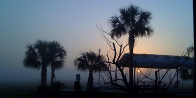
Sunrise today at the Florida Ridge
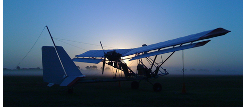
Sunrise earlier this week (can't remember which day - it's all a blur!)
=========================================================================================================================
GPS track-logs / Flytec & Brauniger flight instruments' track-logs and downloading to PCs and Macintoshes and Linux computers: - there seems to be A LOT of discussion here at the hang-gliding competition(s) about this subject, - here are three links for software for the Macintosh, just in case you are interested:
=========================================================================================================================
YES - YES - YES - we're considering (but not seriously, perhaps) moving (again (yeah - 5 years in one place may be too much (now that we have the yard and the irrigation like we want them... - plug this string: 32801 US 441 North, Fort Drum, Florida into 'Google Maps' - and you'll find the place west of US-441 - there's an airstrip, some riding, and mostly some 2.5 acre lots - we'll see - let you know if / when this all develops?!?!?!?!
Mr. Bill's best hang-gliding-flight (Ever) - see the FlightLog.Org web-page, here...
We went to the "LOST" today (LOST = Lake Okeechobee Scenic Trail) and rode a long way - Mr. Bill did 55.6 miles, Ms._May did about 46 miles - it was long and hot (but no dust and not much sun (mostly overcast, though the last hour was sunny and HOT) and not much wind (less than 3 mph all morning (we rode from about 07:30 a.m. til abut 12:30 p.m. - about 5 hours)).
Track-log-file(s): ...kml ...gpx overlays: small medium hugeomongously_BIG
We visited for a few minutes with our friend Mr._Gary from _Okeechobee_, whom we met while riding on the dike. He thought Ms._May was 'virtual' but now that he has met her he realizes she's real...

it was "One of those Days" where one can not find the beginning or the end of the sky or the 'horizon' (the water), reminds me of the Jim Carey movie where he was raised on the set of some TV show, but he didn't know it - and he set-sail across the lake one day and ran-into the far-wall... - Don't remember the name of the movie but it was 'o.k.', but when one looked at the lake and the sky today - it was really hard to tell...

Oh, and here's someone ELSE (read below) who was trying to cross the dike, today...
Friday, 29th: - a short (44 mile) trike-ride today - managed to see quite a few turtles crossing various roads
small turtle picture here larger turtle picture here
a couple of crabs (doing the same thing) some squirrels, birds, lizards, and various & sundry other wildlife (as one normally does). The turtles, though, were a particular treat (it's rained a LOT, lately, so we expect they are looking for drier domiciles?), especially when one has to park one's trike in the middle of the street to let the toi-toi finish crossing the road.
Several drivers, though, helped other turtles crossing other roads. Drivers tend to be more impatient than turtles, who seem to have 'all day' to cross a single road?
AND I found a 'geocahe' yesterday - and stopped, today, to take a picture and such... The one I found was " GC1A41W " - which you can review either with the "Track-Log-File" taken today ( ...kml version or ...gpx version ) - or you can use the " Geocaching Web Site here " to review geocahes, that have been set-up and/or learn-more about this interesting, educational, and growing 'sport' where technical knowledge and sophistication works alongside personal 'stick-to-it-iveness' amongst other positive personal traits to be excellent at this endeavour...
and - lastly - images of the track-log of the ride, today (44 miles is 'not bad' but not 'a personal best' - maybe Sunday might do 60 or 70 miles))
small ( 352 k bytes) medium ( 796 k bytes) super-duper-larger ( 1.2 megabytes)
Friday, 29th: An 'end-of-a-life' here at the Beach Club - but no "Murder Mystery"...

Apparently the mangoes are now ripe - it's NOT a 'mystery' as to who is eating them during the darkest-hours, around here. MAYBE we'll get a few more than we got last year...
The "new Kiln" might show-up today - it was supposedly shipped from New York on Tuesday. However, we have not had a phone-call about the delivery, so who knows
It rained AGAIN last night - more and more and more rain - we'll have to 'do some serious weeding' here really soon - as somehow the raindrops fall ONLY on the weeds, not on the grass.
AND _ the trike-riding continues - about 24.2 miles yesterday - late morning - and found that the 'tea-flavour' of the PowerBar Endurance Drink is not the most tasty stuff in the world, but it really does a good job of hydrating, - better that "G"... - but our experimentation continues...
AND - well - we continue to long for more wind to go kiteboarding in - perhaps a 'positive' thinking attitude will help - but one knows one can rarely influence the weather, even with positive thinking...
The last day of the '3-day-Memorial-day-weekend'...
Monday, 25th May, - short trip up the Loxahatchee River in our kayaks ... - take your pick of the pics (some by Ms._May(Nikon), some by Mr._Bill (iPhone)) - we'll leave it up to you to figure out which is which... ... ...
- Loxahatchee River Trip - Bill 1
- Loxahatchee River Trip - Bill 2
- Loxahatchee River Trip - Bill 3
- Loxahatchee River Trip - bird_1
- Loxahatchee River Trip - golf cart in the river (aren't you glad your 'hangers-on' don't do this!)
- Loxahatchee River Trip - Ms._May with leaves in her face (1)_bad-picture by Mr._Bill
- Loxahatchee River Trip - Ms._May with leaves in her face (2)_worse-picture by Mr._Bill
- Loxahatchee River Trip - Ms._May 1_taking a picture of something beautiful
- Loxahatchee River Trip - scene 1
- Loxahatchee River Trip - scene 2
- Loxahatchee River Trip - scene 3
- Loxahatchee River Trip - toi-tois in repose in the sun
- Loxahatchee River Trip - (GPS track-log on top of Google Earth satellite image) ( small_(305k_bytes) large_(1 meg) huge (3.1 megs) )
- Loxahatchee River Trip - the ...kml file if you want it (only useful if you already have Google Earth on your computer...
Sunday, 24th May;

- had an amazing trike-ride, today - 'longest' for me, ever - 52.2 miles / 4 1/2 hours (or so) - but lost a piece of one of my flags / flagstaff - ugh ugh - drove around quite a while in the car, still didn't find it - ugh ugh UGH... - but - well still a great ride - and though it was overcast it didn't rain and I didn't get cold at all - though I did have to stop twice and pump-up the right tire , then eventually changed the right tube when I said I just was NOT going to stop a third time to pump it up - so I changed it! (but - eventually (at home) found a huge piece of glass in the tire (which explains why two tubes went flat!) Did some maintenance work on the Trike - replaced 'factory' plastic rim-strips with cloth rim-strips - and re-inflated all tires to 65 psi - and - CLEANED it UP - riding on wet-roads makes the trike DIRTY...
- track-log in ...kml format - ( useful if you have Google Earth already installed )
- track-log in ...gpx format - ( useful if you have other mapping tools already installed )
- track-log on top-of a Google Earth satellite image ( small large (1 meg) huge (2.1 megs) )
- Excel spreadsheet of trips / mileage / etc - statistics you are PROBABLY not interested in...

AND - AND - AND - Ms. May was alert and awake and HERE when our cactii blossomed this morning - and she took this picture... - NOTICE all the honey-bees on the flowers - Ms. May says the honey-bees really like these flowers - and they don't just go IN and come OUT - they go INTO the flower and stay there a long time (I'm guessing because Honey Bees like HONEY-making pollen and these flowers are only open a little while (1-4 days, usually) and so the honey-bees are trying to get all they can...
HoneyBees remind me of Mr. Pooh Bear - a Bear of Very Little Brain (kind of like Mr. Bill) (Silly Bear!)
Today is Friday, 22 May
We have had 'some' excitement (a LOT of RAIN all WEEK) that has thrown our normal (great windy days) into oblivion because of the thunder and lightning
Even though we got new pieces and parts for Ms._May's new kiteboarding-control-bar ( hers on the left (small) , mine on the right (large)), and I rigged all that up for her... after her short but excellent kiteboard episode on the 17th... ( large small )
Even though I rode my trusty trike in the RAIN for 3 1/2 hours - (UGH UGH!) track-log-here: large small
Even though we just put in this new irrigation system, but now it has RAINED for almost a week, non-stop. (This may be why it rained; because we have a new irrigation system?)
Even though I'll just BET some silicon supplier put a little tiny 'chip' inside EACH rain drop so that a week's worth of rain fell ONLY on the WEEDs, and not on the (pathetically little) grass that we have, so now there will be little to mow, but lots to weed
Even though I THINK, that now maybe our mangoes will ripen and we'll get more than we got last year...
WELL - more days of holiday to come!

and doesn't look like much hang-gliding on Monday (and Sunday looks even worse)
Today is Friday, 15 May

picture of 'part of' the 'new (and improved)' irrigation system in our front yard...
Yesterday there was 'just enough' (but not more than enough) wind for Mr. Bill to get some excellent kiteboarding in, (after 3 hours of digging-ditches yesterday morning and before 2 hours of 'gluing' the new irrigation system together last evening...
Today is Monday, 11th May, and we're here in Stuart, - home-sweet-home...
The "2009 Flytec Race-Rally Hang Gliding Competition" ended at "Quest Air" in Groveland, Florida (just west of Orlando, Florida) on Saturday evening, the 9th... The event was 'supposed' to end at "Lookout Mountain Flight Park" in Rising Fawn, Georgia (about 20 miles south of Chattanooga, Tennessee) but - well - the weather reared it's ugly head and the bulk of the participants drove back to Quest Air and finished the last two 'tasks' there...
AND - of course the " (First) Rob Kells Memorial Hang Gliding event is now over at "The Florida Ridge" - one can view results here:
Flex-wing glider results (Flex-wings are the most popular, low cost, (like $4,000 - $10,000 and the type that Ms._May and I own)
Rigid-wing glider results (Rigid-wings are for 'REAL PEOPLE' (mostly guys!)) - and big, heavy, (fast) and expensive (like $10,000 - $45,000)
Sport class glider results (Sport Class is for beginners at cross-country (like me - this is where I would compete if I were 'up to it' (which I'm not))
Ms. May took some pictures of that event on Thursday morning, 30th April, while we were launching the pilots / gliders. Those images are now in my "Gallery" (web) page here...
Saturday, (9th) and today (11th) were TriceQ riding days and they were excellent with 31.7 miles and 23.4 miles (respectively)... Had yet one more flat-tire - I think I must be doing something wrong, here??? - Will have to investigate & change my habits, I guess...
We both went hang-gliding on Sunday, 10th (Mother's Day (did you phone your mother????)), and Mr. Bill set a new 'personal best' height record of 7,634 feet (about 7,600 feet above the field at "The Florida Ridge").
I probably could have made the extra 400 feet or so to get to a new personal best of 8,000 feet, but I most probably would have been an icicle and I would DEFINITELY have been INSIDE a cloud; neither of these options is a 'Good Thing' when you're hang-gliding. It was an hour and 41 minute flight for me...
A REAL record was set by Mr._Brad, one of the other (local (Ridge)) pilots, 9,000 something feet - and WOW that's (really) high for Florida (at this time of year (or actually that's HIGH for Florida at ANY time of year) and a new record for a "Florida Ridge" pilot. On the other hand, Mr._Brad is a pretty spectacular pilot. Another local pilot (Eric) set his new personal best at 8,300 feet.
Ms. May took some excellent pictures of me landing after one of my flights on Sunday, 10th. Those pictures are on the Gallery site here...
Ms. May also had a good flight - no personal bests, there, but a good flight never-the-less. It was terrific to see the huggly-bunch in the air, again, as it's been quite a while for her... Today was the first day that she used the Garmin GPSMap 76CSx to create a 'track-log' of her flight. There's two 'simple' images, here, with (one of) her track-logs overlain on top of a 'Google Earth' satellite image:


Ms. May's first flight at the "Ridge" on Sunday, 10th Ms. May's second flight at the "Ridge" on Sunday, 10th...
Now that I've downloaded those two flights' track-logs, I'm still attempting to get the 1/2 dozen different pieces of software on the 1/2 dozen different computers to exhibit 'just the right' set of characteristics... - UGH UGH - modern technology, you know....
However, I have (now, reliably) figured out how to get 'curtained' track-logs in Google Earth / overlain on top of the satellite imagery provided by Google Earth...
The following image of of Ms._May's short (first) flight on Sunday, 10th is in this format. However, you may or may not 'make sense' of this format if you are not a pilot.
- small curtained image ( 600 k bytes)
- larger curtained
image ( 1,1 mega bytes)
1.) I'd like to be able to offer a 'click here link' so that our friends & relations can view "in 3D" the track-log files - which of course have that 'extra dimension' (altitude)
2.) I'd like to be able to offer a 'click here link' so that our friends & relations can see an 'animation' of our flight(s) along the 3D path - expressed or offered in Google Earth
I can not, now, do either of these things "RELIABLY" _ I've done each but only in different software tools - primarily on the Windows XP platform, with only pieces available to the Macintosh (PowerPC) platform user? - HOWEVER, I know that as time goes by and as I get more proficient (and maybe lose more hair) that 'all things will be possible'!
Today is (early (EARLY)) morning of Wednesday, 6th May, and this morning the 'Flytec Race Rally' is in Moultrie, Georgia... (over 1/2 way to the finish at Lookout Mountain Flight Park near Trenton, Georgia, and if you can't find that on the map, it's about 20 miles south of Chattanooga, Tennessee...
Anyway - NO ONE made it to "goal" on Tuesday (going into Williston, Florida) and NO ONE made it to "goal" last night coming into here (Moultrie, Georgia)... Most of the gang went-down 'around-about' Live Oak, Florida - very near to the intersection of US Interstate 10 and US Interstate 75 (VERY BIG Highways!)...

When I picked-up Ms._Linda, she had a LOT of help breaking-down her glider.
Then we had dinner (excellent sub-sandwiches) in Quitman, Georgia and when we drove into Moultrie last night about 8:30 p.m. or so there were a LOT of wet - streets roads, and we set-up the pop-up-trailer in the drizzle...
This morning - it's still raining / misting a 'bit' and a the Moultrie Airport, here, there is some definite fog...
For results of this event you can go to: http://soaringspot.com/flytec2009
For more information from the "Source" you can find Ms._Linda's "Blogspot" here.
Today is Monday, 4th May, and the second day of the Flytec Race-Ralley Hang Gliding event - yesterday's field had about 2/3 in goal (of over 200 km)...

Sunrise at Quest Air in Groveland, Florida (near Orlando)...
I'm doing a lot of driving - these days (that's what they pay me for, anyway) - will do a lot more - in the past my lovely and talented wife / navigator has helped me a LOT... I'm now driving for a terrific couple of pilots from western New_York, and they have kind of a small car, and Ms._May did not want to come, anyway.

So the couple felt sorry for me and found me a "" driving partner "" - she's very good at keeping quiet, but she's not the best (opposing thumbs and all that stuff) with the navigation & communications tools (GPS, radio, cell-phone, etc.), and she doesn't like french-fries but she DOES LIKE fish sandwiches... She also has a great 'body-mass' which helps keep me warm on the cold evenings...
Today is Sunday, 3 May, and the first day of the Flytec Race-Rally Hang Gliding event - we'll only know tonite how successful this first day was / is... This is a 7 day / 700 mile (if the weather cooperates and we make it all the way) event. This format has never been attempted in the USA - so wish us luck!!!

However, here's a sunrise picture
ALSO: - today - nearby to The Florida Ridge flight park will be a fairly big paragliding event, they practiced yesterday and it was a very impressive sight to watch one of their best in class pilots (and the organizer of the event) land here at the flight park - it's not yet 07:30 a.m. and they are already practicing, here, there, and nearby...
Well, today is Saturday, 2nd of May and not much has happened, yet.... - I'm here at "The Florida Ridge" (a 'flight park') where the 'First Annual Rob Kells Memorial (he died of prostate cancer last year) Hang Gliding Competition' has just concluded (yesterday)... and where tomorrow (Sunday, 3 May) the "Flytec Race Rally" will begin.
The 'Race-Rally' is a new and different format for a hang gliding competition. This format, imagined and created by Ms._JS_ will happen over a period of a week of flying and will start here and end at "Lookout Mountain Flight Park" on 9 May (next Saturday) This means that the pilots will hang-glide / fly about 700 miles in about 7 days - it also means that I'll drive about 700 miles (PLUS) in traffic congestion, intersections, stop-lights, etc. (they fly, basically in a straight-line at whatever speed they like, I drive on roads - ugh - ugh - - but - we'll GET THERE!
This 'assumes' that the weather cooperates and the wind basically blows out of the south for a week of flying... (There are a WHOLE LOT of 'atheists' who are praying for the right weather conditions - we'll see if their 'prayers' are answered... I'm driving for a great guy & gal out of western New_York, and spent last night in the un-used half of their 'pop-up-trailer' (it was VERY COMFY!) ... ... ...

Sunrise today at the Florida Ridge

Sunrise earlier this week (can't remember which day - it's all a blur!)
=========================================================================================================================
GPS track-logs / Flytec & Brauniger flight instruments' track-logs and downloading to PCs and Macintoshes and Linux computers: - there seems to be A LOT of discussion here at the hang-gliding competition(s) about this subject, - here are three links for software for the Macintosh, just in case you are interested:
- this package (called "GPS-Babel") is multi-platform (it runs on PCs, Linux, Macintoshes): http://www.gpsbabel.org
- this package is a 'bit more generic' and it's user-interface is a bit more Macintosh centric): http://www.cluetrust.com/loadmytracks.html
- this package is specifically for the Macintosh OSs and it's a bit old, and it's a soaring-package but will also do downloading: http://www.flighttrack.sourceforge.net
- Keyspan (now marketed by "Tripplite" (old-part-number: USA-HS-19)): link to Tripp-Lite-web-page-item
- Belkin - link to web-site-page:
=========================================================================================================================
YES - YES - YES - we're considering (but not seriously, perhaps) moving (again (yeah - 5 years in one place may be too much (now that we have the yard and the irrigation like we want them... - plug this string: 32801 US 441 North, Fort Drum, Florida into 'Google Maps' - and you'll find the place west of US-441 - there's an airstrip, some riding, and mostly some 2.5 acre lots - we'll see - let you know if / when this all develops?!?!?!?!
Mr. Bill's best hang-gliding-flight (Ever) - see the FlightLog.Org web-page, here...
and-or see the
track-log over Google Earth Image(s), here... small_image
larger_image
(1 megabyte)
Archived BeachWeb monthly site(s): Click here for a list of the archived months
Some people have asked, WHERE can I FIND, "X" - whatever the heck "X" is?; but in my case - these two things are being asked about...
The "Tire Changing Web-Page" and/or the VANC (VikingAsia (Networks and Computers) Consulting) web-page.
AND / OR if you 'WANT' (or desire or need or have an 'urge' for something you don't see, then you can e-mail me at: bill@vikingasia.org
updated: 14:08 p.m. on Sunday, 31 May, 2009 (Stuart, Florida) - revID:
1r